* Hokkaido Travel Tips的部落格
收集並保存0圓觀光景點和部分需付費的必看景點,而且也介紹美食及土特產的情報。

*Hokkaido Travel Tips’ Blog
We compile information on “0 yen tourist spots” and “must-see paid spots with extra benefits” and then keep them in our blog as archives for your convenience. We also introduce the food of Hokkaido and interesting souvenirs to take home.

www.hokkaidotraveltips.com

2018年6月20日水曜日

火山資料展示室 / The Exhibition Room of Volcanic Materials of Mt. Usu

火山資料展示室(位於洞爺湖町)比鄰於在2000年有珠山噴發時,因國道230號道路下陷而形成的西新山沼。當時,這個建築物是洞爺湖區域的消防局本部。為了要展示火山的資料而再度使用這個建築物。特地保存了當時地板稍微傾斜的狀態。有照片等相關資料。

The Exhibition Room of Volcanic Materials of Mt. Usu (Toyako Town) is next to Nishi Shinzan Numa, which is a big pond created by the volcanic activity of Mt. Usu in 2000. After part of route 230 caved-in, the pond was created. The building housing this exhibition room used to be the headquarters of fire defense for the area around Lake Toya. After it was damaged, the headquarters moved to the different location. The building then became the present exhibition facility, although the floor is slightly off flat. There are many photos to inform people of what the volcanic activities in 2000 were like.


煤礦的大露頭 / Sekitan-no Dai Rotou

煤礦的大露頭(位於夕張市)是北海道指定的天然紀念物。1888年,在地面上發現了高達7公尺以上的裸露的煤炭地層。此發現造就了夕張市成為煤礦產地主要都市的契機。現在這個地點緊臨於煤礦博物館的停車場,可以自由參觀。煤礦博物館於20184月整修後重新開幕。

Sekitan-no Dai Rotou (Yubari City) is designated as a prefectural treasure of Hokkaido. Sekitan means coal and rotou means outcrop; and Sekitan-no Dai Rotou stands for a large-scale outcrop of coal. In 1888, an exposed coal layer, in excess of seven meters in height, was discovered. This saw the bitrh of Yubari becoming one of the main coal mining hubs of Japan. Sekitan-no Dai Rotou is now located next the parking of the site of the Coal Museum. Although the museum is paid, this site is free to see. The Coal Museum was renovated in April, 2018.


Kinema Kaidou

Kinema Kaidou (電影街道,位於夕張市)是以電影為主題的大道,靠近夕張市政府。在大道的各處設置電影史上留下名聲的著名老電影的看板。不管哪一種看板都是昔日很普遍的手繪看板,令人感受到懷舊的氣氛。夕張也是舉辦過電影節的電影之都。煤礦產業興盛的時候,市內曾有17家電影院。
Kinema:從英文的cinema 而來,意指電影;Kaido:為日文發音的「街道」。

Kinema Kaidou (Yubari City) is a cinema-themed street near Yubari City Hall. Kinema Kaidou stands for ‘Cinema Street,’ with this street exhibiting large billboards of many old classic movies. Those billboards, which were standard at movie theaters back in the day, are all hand-drawn, are a far cry from modern times. These billboards from 50s and 60s remind us of the good old days. Yubari was one of the cities which flourished on the back of coal-mining, and there were 17 theaters in Yubari’s heyday. Now, Yubari holds an international movie festival every year. This street can give us a sense of when Yubari shined, and people enjoyed a day or night watching movies.


昭和新山 / Mt. Showa Shinzan

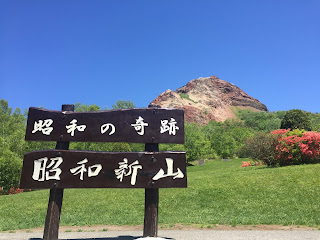
昭和新山(位於壯瞥町)是特別天然紀念物的活火山。1944年時,在私有田地的一部分隆起。之後僅僅一年隆起的部分越來越高,於1945年停止火山活動。現在的高度為398公尺。從平地變成火山的過程被記錄下來,可以說是非常珍貴的火山。田地的泥土因為熔岩的熱度被燒烤的像磚塊般的堅固,山體表面看起來是赤紅色。

Mt. Showa Shinzan (Soubetsu Town) is an active volcano which has gained recognition as a special national treasure. As a record of the entire seismic and volcanic history of the mountain since its creation in 1944 has been recorded, it’s a rare volcano. In 1944, a part of a privately-owned field rose up. Within the space of only a year, it grew and grew, bigger and bigger, and became a mountain. In 1945, the activity stopped, with the mountain at its present height of 398 meters. The color of Mt. Showa Shinzan is red-brown, because the soil of the land was heated by the heat of lava. It’s like when red bricks are fired in a kiln.


西新山沼和舊國道230號線 / Nishi Shinzan Numa and the former route 230

西新山沼和舊國道230號線(洞爺湖町)是2000年有珠山噴發時的受災地之一,現在變成了著名觀光景點。當時的國道230號被破壞到已經不可能恢復原狀的程度,因此轉移到不同的地點。陷下去的道路聚集了水變成了沼澤。可以觀察到隨著火山活動造成大地變動的樣子。

Nishi Shinzan Numa and the former route 230 (Toyako Town) are examples of local infrastructure which sustained damage from the 2000 Mt. Usu eruption. These locations are now transforming into sightseeing spots. The eruption caused some areas of the land to either elevate or collapse. A part of route 230 caved-in and then turned into a big pond, after years of rainfall filled it up. This is Nishi Shinzan Numa. You can learn about the power of volcanic activity at this site. Nishi means western part, and shinzan stands for a new mountain.


洞爺湖有珠山地質公園 / Toya Caldera and Usu Volcano Global Geopark

洞爺湖有珠山地質公園是日本最初的地質公園,在20098月由Global Geoparks Network所登錄的。公園因火山活動所形成的地質和自然受到了評價。有建設好在大自然當中的健走行程(標註著提醒標誌),也有約20處的展示學習設施(博物館)。
Global Geoparks Network:是在UNESCO的支助下設立的國際組織。從地球科學的角度來登錄重要的地點。

Toya Caldera and Usu Volcano Global Geopark was the first geopark in Japan, as designated by Global Geoparks Network in August, 2009. The unique geological features created by volcanic activities and the surrounding nature were acknowledged to be worthy of reserve. There are well-managed walking trails, approximately 20 museums and information centers for the study of geoscience and/or geoheritage, and many outdoor sightseeing spots. 
The geopark spreads over Date City, Toyoura Town, Soubetsu Town and Toyako Town.
Global Geoparks Network is an international organization set up in 1998 with the assistance of UNESCO. They register important geoscientific sites around the world.

http://www.toya-usu-geopark.org


有珠山噴火紀念公園 / Mt. Usu Funka Memorial Park

有珠山噴火紀念公園(洞爺湖町)建造的目的是為了留下2000年時所發生的火山噴發時的回憶。當時的火山噴發雖然造成土地的隆起和下陷等基礎建設的巨大災害,但死亡人數為0人。這個公園的象徵是人類的臉部雕刻「月之光」。是面向湖面寂靜的場所,推薦來這裡作日光浴或野餐。垃圾必須自己帶回家。

Mt. Usu Funka Memorial Park (Toyako Town) was established in memory of the Mt. Usu eruption in 2000 (funka means eruption.) This eruption badly damaged local infrastructure such as roads and electricity, but there were fortunately no deaths. A lot of volcanic ash was used in the construction of the park. It faces Lake Toya and houses some sculptures in a quiet environment. The Moonlight (1991) by Igor Mitoraj, a well-known Polish artist, is the icon of this park. Sunbathing or picnicking are good ways to enjoy the park. Garbage must be taken away by visitors.


有珠山 / Mt. Usu


有珠山雖然是位在洞爺湖南側標高737公尺的活火山,但是可以去到山頂的區域。可以瞭望到昔日的火山噴發口。眼下的洞爺湖和昭和新山十分壯觀。前往山頂區域有兩種方法,爬山前往免費,使用纜車則需要費用。登山的平均時間為上山90分鐘,下山60分鐘,是個可以輕鬆攀爬的山,搭乘纜車單程所需時間為6分鐘。

Mt. Usu stands 737 meters high at the southern end of Lake Toya. Despite it being a volcano, people can get very close to the summit. Visitors can look at the crater left from a previous eruption from an observation point. Lake Toya and Mt. Showa Shinzan can also be seen below. There are two ways to reach the summit area of Mt. Usu, either by walking up the trail or via the ropeway. The trail is free, and it takes approximately 90 minutes to ascend, and 60 minutes to return. Mt. Usu is enjoyable for mountain trekking beginners. The ropeway takes six minutes one-way.


紫藤花 / Wisteria flowers

北海道的賞花信息「紫藤花」
在札幌紫藤花的最佳觀賞時節是在5月下旬到6月上旬。紫藤花是攀緣植物的一種,幾乎都會在公園內設置紫藤花專用的棚架。可以欣賞到頭頂上方的紫色花朵。除了前田森林公園(手稻區)和中島公園(中央區)之外,天神山綠地(豐平區)等地方也有紫藤花的棚架。鄂霍次克地區的遠輕町丸瀨布有北海道內規模最大的紫藤花棚架。

Hokkaido Flower Information
Wisteria flowers
The best season for seeing wisteria flowers in Sapporo is between the end of May to the beginning of June. As wisteria is a climbing plant, sightseeing spots for wisteria are almost exclusively in parks. People can see trellises with beautiful wisteria flowers overhead. They create a green and purple ceiling which can block the strong sunlight. The remaining filtered sunlight seems to have mysterious curative properties. In Sapporo, Maeda Forest Park, Nakajima Park are famous for wisteria as well as Tenjinyama Green Space. At Maruseppu in Engaru Town on the Sea of Okhotsk, the biggest wisteria trellis in Hokkaido can be found. The peak season may be later there than in Sapporo.